Difference between revisions of "Marshfield Coastal Adaptation Annotated Bibliography"
(→Historical Maps: added 1870-era map reference) |
m (→Historical Maps) |
||
| Line 113: | Line 113: | ||
* 1838 Map of Marshfield, showing dwellings and roads (Harvard Geospatial Library) | * 1838 Map of Marshfield, showing dwellings and roads (Harvard Geospatial Library) | ||
* 1857 Map of Plymouth County (Harvard Geospatial Library) | * 1857 Map of Plymouth County (Harvard Geospatial Library) | ||
| − | * | + | * 1879 Map of Marshfield, showing dwellings and roads (for example, in lobby of Marshfield Orthodontics office) |
* circa 1900 "historic 15-minute USGS topographic map of the Duxbury, Massachusetts quadrangle. The survey date (ground condition) of this map is 1885, the edition date is September, 1893 and this map was reprinted in 1931" (Harvard Geospatial Library) So, supposedly 1885, but it shows the river mouth north of Humarock, which dates it after 1898. | * circa 1900 "historic 15-minute USGS topographic map of the Duxbury, Massachusetts quadrangle. The survey date (ground condition) of this map is 1885, the edition date is September, 1893 and this map was reprinted in 1931" (Harvard Geospatial Library) So, supposedly 1885, but it shows the river mouth north of Humarock, which dates it after 1898. | ||
Revision as of 12:51, 28 February 2014
This website is still in active development.
This website is an annotated bibliography for tracking interesting research articles, news coverage, references, and online resources relevant to issues of climate change adaptation in the coastal community of Marshfield, Massahcusettes, USA. Much of it will likely be useful for other communities in a similar situation.
The information here has been gathered and edited by the members of the Town of Marshfield's Coastal Advisory Committee, which reports to the Town's Board of Selectmen. The site is hosted by committee member Dr. Sean P. Robinson, with thanks to the Helena Foundation Junior Physics Laboratory in the Department of Physics at the Massachusetts Institute of Technology.
This bibliography represents a partial response to those line items in the Committee's mission statement which pertain to educating the public on the complicated issues of climate change and adaptation. It also summarizes the Committee members' efforts to advance their own knowledge of adaptation strategies to sea level rise and related climate change phenomena in coastal communities like Marshfield.
This website is very much a work in progress. (Page started October 2013.)
Contents |
Agencies and Organizations
Management of coastal risks involves a complex set of public agencies and private partners. The following is a partial list of some of the involved parties. In the future, this list will be expanded with commentary on the roles of each of these bodies and how they relate to each other in regards to managing coastal adaptation.
Government
- Town of Marshfield (Town Admin, Town Planner, Board of Selectmen)
- Coastal Advisory Committee. See CAC Work Plan.
- Energy Committee
- Waterways Committee
- DPW
- Conservation Commission
- South Shore Coastal Hazards Adaptation Study
- Sea Level Rise Study Duxbury, Marshfield, Scituate, MA Presentation Slides (Kleinfelder) 16 May 2013 and the actual report (27 MB PDF file)
- Press release about the study presentation
- Towns tackle sea level rise Marshfield Mariner 23 May 2013
- State
- Federal
- ACE
- EPA
- FEMA
- NOAA
- NWS
- NASA-GISS
- FWS
- See the Coastal Barrier Resources Act web page: http://www.fws.gov/cbra/
Private
- Marshfield Citizens Coastal Coalition
- Duxbury Beach Reservation
- Sacrificial Dune Role in Coastal Barrier Protection, Solutions to Coastal Disasters 2005: pp. 344-353. doi: 10.1061/40774(176)35
GIS Resources
Geographical Information Systems, or GIS, is a set of technological tools for placing data layers on maps. Basic skills in and access to GIS tools are essential to any research-based approach to coastal adaptation. The following set of links may help people get a start in casual GIS usage, although professional level applications of GIS often require expertise derived from extensive training and fairly powerful computers running expensive, specialized software.
- Marshfield Online GIS
- MassGIS, Massachusetts GIS services.
- The 600 pound gorilla of the GIS software world is ArcGIS. The personal use version is around $100/year. The fully powered version is typically licensed by institutions for an order of magnitude more dollars than the personal version. QuantumGIS is a free, open source alternative.
Climate Change and Adaptation
One of the principle drivers (but not the only one) of the need for adaptation measures in coastal communities is climate change. Therefore, a solid grasp of the scientific understanding and explanation of climate change is necessary for making educated judgments about coastal adaptation. Unfortunately, the vast majority of the information most readily available to the public on this subject is of a quality that ranges from unusably oversimplified to outright bogus, although the communication skill of the media outlets or political pundits reporting the information may give it the illusion of reliability. Much of this media reporting also couches the reporting of climate change science within a political "pro versus con" narrative which is absent in the science itself, but presumably makes the story more entertaining for its readers. (Incidentally, media reports of both the "pro" and "con" variety are equally subject to the lack of reliability cited above.) The Coastal Advisory Committee hopes to be able to sort through and present some of the available content on climate change and adaptation measures which is reliable, accessible, and relevant for residents of coastal communities like Marshfield. At present, this content is just the loosely organized set of references below, but should be refined and expanded with explanatory language as time goes on.
Web Sites
- American Geophysical Union Position Statement on "Human Impacts on Climate"
- "The Discovery of Global Warming", a history by the American Physical Society. See also the AIP positon statement on climate change.
- University of Maine Climate Change Institute
- Adaptation to Abrupt Climate Change IGERT Program, also http://a2c2igert.umaine.edu/
- A2C2 people
- Mo Correll's work on abrupt climate change in Atlantic tidal marshes.
- The Climate Reanalyzer Run your own maps and visualizations!
- The Clilmate Change National Forum, a "new journalistic endeavor" which "will be to provide a public forum wherein scientists can discuss the latest research on climate change and share and debate ideas on aspects of climate change especially relevant to policymaking."
- Global Warming and Climate Change Myths
- Younger Dryas (Wikipedia), a commonly cited example of "abrupt climate change", in contrast to "gradual climate change", such as the long slow warming trend since the end of the last glacial maximum 20,000 years ago. The Younger Dryas event lasted about 1300 years (12.8--11.5 thousand years ago) and mostly affected high northern latitudes. It was a temporary return to glacial conditions. It is remarkable in that the transition from interglacial to glacial conditions appears to have occurred over less than 10 years.
- www.coastalengineering.org Coastal Engineering Resources link page
- WHOI Changing Shorelines & Erosion
Research Articles
- Coastal habitats shield people and property from sea-level rise and storms, Nature Climate Change Letters 14 July 2013 (paid access), 7 pages. Plus supplementary information, 45 pages. Also, media coverage.
- Protection of Coastal Infrastructure under Rising Flood Risk, Joint Program Report Series, 2013, 23 pages.
Books
- High Tide on Main Street, by John Englander, 2nd Ed, 2013,
News and other Press
- Marshfield receives $1.25 million seawall grant Marshfield Mariner, 14 January 2014
- Sandy task force says spend now for future storms Boston Globe, 20 August 2013.
- The Beach Builders: Can the Jersey Shore be saved? The New Yorker, 22 July 2013.
- White House 2013 clean energy bill promotional materials and extended climate/energy infographic. It speaks more about the prevention side of climate change than the adaptation side, but there are some interesting notes on adaptation, too. It's not a lot of detail in terms of being useful for policy advising, but it could be useful in our public education efforts. Note the state-specific links at the end. The Massachusetts report is only 2 pages.
- Maine Lobsters Threatened By Climate Change, Says New Campaign Huffington Post (AP) 2 July 2013.
- Chappaquiddick mansion: Man vs. sea vs. neighbors Boston Globe 28 April 2013.
- Plum Island Homeowners Ignore State Regulations, Shore Up Homes WBUR 22 March 2013.
- Luhrs v. Whatcom County (March 2011) Press release from the Pacific Legal Foundation regarding a 2011 Washington State legal case where an individual homeowner successfully fought for the legal ability to build a stone revetment to secure the eroding coastal bluff at property edge, against the wishes of the county permitting bodies. Legal argument based on Washington State Constitution and statute.
Historical Marshfield
It seems that people have not always built their homes in the vulnerable coastal areas of Marshfield. It's a relatively recent thing, where "recent" is less than about 150 years. But, exactly when and why did this start? Understanding the answer to this question would help with two areas of relevance to coastal adaptation today:
- decipher what the "natural" profile of Marshfield's coastal areas might look like without coastal protection structures and land development, and
- bring some perspective in judging which adaptation strategies are "reasonable" in the big picture that extends beyond the limited scope of experience of today's residents.
Historical Resources and Groups
- Town of Marshfield Historical Commission
- Marshfield Historical Society
- marshfield.net history page
- Marshfield Chamber of Commerce history page
General Histories and Contemporaneous Descriptions
- Memorials of Marshfield: And Guide Book to Its Localities at Green Harbor (free ebook) by Marcia Abiah Thomas, 1854, 108 pages.
- Excerpt from Massachusetts Gazetteer by Nason and Varney (1890)
- History of Marshfield, Vol 1 (free ebook) by Lysander Salmon Richards, 1901, 242 pages. See especially the end of Chapter LV.
- History of Marshfield, Vol 2 by Lysander Salmon Richards, 252 pages.
- Massachusetts Historical Commission Reconnaissance Survey Town Report: Marshfield (1981)
- Marshfield: A Town of Villages 1640-1990 (book) by Cynthia Hagar Krusell (1990).
- Images of America: Marshfield (book) by Cynthia Hagar Krussell and John J. Galluzzo (2007).
- Marshfield Historical Photos on Flickr!
Historical Maps
- 1776 Boston and Vicinity, not very accurate (Harvard Geospatial Library)
- 1781 Nautical Chart of Plymouth Bay (Harvard Geospatial Library)
- 1838 Map of Marshfield, showing dwellings and roads (Harvard Geospatial Library)
- 1857 Map of Plymouth County (Harvard Geospatial Library)
- 1879 Map of Marshfield, showing dwellings and roads (for example, in lobby of Marshfield Orthodontics office)
- circa 1900 "historic 15-minute USGS topographic map of the Duxbury, Massachusetts quadrangle. The survey date (ground condition) of this map is 1885, the edition date is September, 1893 and this map was reprinted in 1931" (Harvard Geospatial Library) So, supposedly 1885, but it shows the river mouth north of Humarock, which dates it after 1898.
Recreational and Residential Buildup
- Several of the above listed general histories contain scattered references to a rapid build-out of real estate in what had previously been the mostly undeveloped coastal areas of Marshfield (now called Fieldston, Ocean Bluff, and Brant Rock; extending partly into the existing villages of Green Harbor and Rexhame) over several decades starting in the 1860s in support of a tourism industry centered on the then-new concept of the sea side resort. Hotels, casinos, and related attractions concentrated around what is now the Brant Rock Esplanade, with the remainder of the build-out seeming to have consisted largely of residential structures intended for a seasonal population rather than permanent homes. Presumably, these beginnings of Marshfield as a tourist destination were part of the larger Victorian trends of keeping a second home near the beach as an upper class status symbol and the emergence of "going to the beach" as a novel recreational activity. It is also likely not unrelated to the arrival of the railroad in Marshfield circa 1870. However, rigorous historical analysis of these guesses is presently lacking. Likewise, there is little historical anlaysis of what brought the era of the Brant Rock hotels to an end, or what socioeconomic dynamics drove the eventual transition to more year-round occupation of the coastal areas.
- The Fairview Inn history page claims that the building originally at the Fairview site was one of six Brant Rock inns built in the 1860s and 1870s.
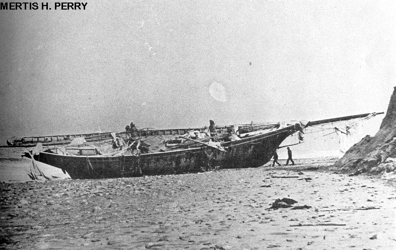
The Portland Gale
The "Portland Gale" is the popular name of a major storm which brought much loss of life and property to coastal Massachusetts in late November, 1898. In Marshfield, it is most notable for having changed the mouth of the North and South Rivers, so that they meet and empty into the sea at the north end of the Humarock peninsula, rather than at the south end (now Rexhame Beach). "The Portland Gale" is the answer to a question which confuses many new Marshfield and Scituate residents: "Why is Humarock part of Scituate when it is only connected to Marshfield?"
- "Warnings Ignored! The Story of the Portland Gale, November, 1898" (book) by F. Freitas and D. Ball (1995).
- A summary and photo feature of the storm and its effect on ships from "Haze Gray & Underway", a historical website about ships and navies.
- Image of the shipwreck Mertis H. Perry after the Portland Gale, near Brant Rock.
NFIP, FIRMs, FEMA, and all that
Coastal adaptation planning focuses primarily on issues several years or decades into the community's future. However, vulnerable coastal communities are already threatened today in a variety of ways. Managing the complex physical challenges of climate change requires that it be understood together with a similarly complex web of economic pressures and governmental regulations from the local to federal level. One example of this is the National Flood Insurance Program (NFIP) managed by the Federal Emergency Management Agency (FEMA). The affordability or otherwise of flood insurance for homes and business in flood-prone areas can have a major effect on determining what type of community can be sustained in those areas. As such, a topical understanding of NFIP is important for coastal adaptation planners. Resources to aid that understanding are documented here. On the other hand, the management of municipal NFIP procedures for a particular mapping cycle, such as FIRM appeals or CRS certification, while critical to the immediate needs of coastal communities, is not itself part of long-term adaptation planning. Timely response to these immediate needs should be addressed through a separate dedicated effort. In Marshfield, NFIP response is handled by the central administration in Town Hall, notably aided by the commendable efforts of the Marshfield Citizens Coastal Coalition citizen advocacy group.
General NFIP resources
2013 Mapping Cycle
News Coverage
- FEMA flood maps online as neighborhoods approach appeals Marshfield Mariner 31 July 2013.
- Flood insurance rates rising Cape & Plymouth Business 30 July 2013.
Maps and Documentation
- MCC's pdf 2013 Draft FIRMs downloads
- 2013 Draft FIRMs from Town Marshfield, slightly different form above.
- Community Rating System Resources. See also the 2013 CRS Coordinator's Manual.