Historical Marshfield
It seems that people have not always built their homes in the vulnerable coastal areas of Marshfield. It is a relatively recent thing, where "recent" is less than about 150 years. But, exactly when and why did this start? Understanding the answer to this question would help with two areas of relevance to coastal adaptation today:
- decipher what the "natural" profile of Marshfield's coastal areas might look like without coastal protection structures and land development, and
- bring some perspective in judging which adaptation strategies are "reasonable" in the big picture that extends beyond the limited scope of experience of today's residents.
Contents |
Historical Resources and Groups
- Town of Marshfield Historical Commission
- Marshfield Historical Society
- marshfield.net history page
- Marshfield Chamber of Commerce history page
General Histories and Contemporaneous Descriptions
- Memorials of Marshfield: And Guide Book to Its Localities at Green Harbor (free ebook) by Marcia Abiah Thomas, 1854, 108 pages.
- Excerpt from Massachusetts Gazetteer by Nason and Varney (1890)
- History of Marshfield, Vol 1 (free ebook) by Lysander Salmon Richards, 1901, 242 pages. See especially the end of Chapter LV.
- History of Marshfield, Vol 2 by Lysander Salmon Richards, 252 pages.
- Massachusetts Historical Commission Reconnaissance Survey Town Report: Marshfield (1981)
- Marshfield: A Town of Villages 1640-1990 (book) by Cynthia Hagar Krusell (1990).
- Images of America: Marshfield (book) by Cynthia Hagar Krussell and John J. Galluzzo (2007).
- Marshfield Historical Photos on Flickr!
Historical Maps
See also GIS Resources. The following maps are known to exist:
- 1776 Boston and Vicinity, not very accurate (Harvard Geospatial Library)
- 1781 Nautical Chart of Plymouth Bay (Harvard Geospatial Library)
- 1838 Map of Marshfield, showing dwellings and roads (Harvard Geospatial Library)
- 1857 Map of Plymouth County (Harvard Geospatial Library)
- 1879 Map of Marshfield, showing dwellings and roads (for example, in lobby of Marshfield Orthodontics office)
- circa 1900 "historic 15-minute USGS topographic map of the Duxbury, Massachusetts quadrangle. The survey date (ground condition) of this map is 1885, the edition date is September, 1893 and this map was reprinted in 1931" (Harvard Geospatial Library) So, supposedly 1885, but it shows the river mouth north of Humarock, which dates it after 1898.
Recreational and Residential Buildup
- Several of the above listed general histories contain scattered references to a rapid build-out of real estate in what had previously been the mostly undeveloped coastal areas of Marshfield (now called Fieldston, Ocean Bluff, and Brant Rock; extending partly into the existing villages of Green Harbor and Rexhame) over several decades starting in the 1860s in support of a tourism industry centered on the then-new concept of the sea side resort. Hotels, casinos, and related attractions concentrated around what is now the Brant Rock Esplanade, with the remainder of the build-out seeming to have consisted largely of residential structures intended for a seasonal population rather than as permanent homes. Presumably, these beginnings of Marshfield as a tourist destination were part of the larger Victorian trends of keeping a second home near the beach as an upper class status symbol and the emergence of "going to the beach" as a novel recreational activity. It is also likely not unrelated to the arrival of the railroad in Marshfield circa 1870. However, rigorous historical analysis of these guesses is presently lacking. Likewise, there is little historical anlaysis of what brought the era of the Brant Rock hotels to an end, or what socioeconomic dynamics drove the eventual transition to more year-round occupation of the coastal areas.
- The Fairview Inn history page claims that the building originally at the Fairview site was one of six Brant Rock inns built in the 1860s and 1870s.
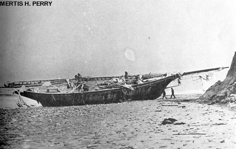
The Portland Gale
The "Portland Gale" is the popular name of a major storm which brought much loss of life and property to coastal Massachusetts in late November, 1898. In Marshfield, it is most notable for having changed the mouth of the North and South Rivers, so that they meet and empty into the sea at the north end of the Humarock peninsula, rather than at the south end (now Rexhame Beach). "The Portland Gale" is the answer to a question which confuses many new Marshfield and Scituate residents: "Why is Humarock part of Scituate when it is only connected to Marshfield?"
- "Warnings Ignored! The Story of the Portland Gale, November, 1898" (book) by F. Freitas and D. Ball (1995).
- A summary and photo feature of the storm and its effect on ships from "Haze Gray & Underway", a historical website about ships and navies.
- Image of the shipwreck Mertis H. Perry after the Portland Gale, near Brant Rock.